Thermal infrared technologies for precision agriculture: A ROSES-guided systematic evidence synthesis on platforms, calibration, and digital analytics
,
a Department of Biological Systems Engineering, Virginia Tech, Blacksburg, VA, 24061, USA
b Tidewater Agricultural Research and Extension Center, Virginia Tech, Suffolk, VA, 23437, USA
Abstract
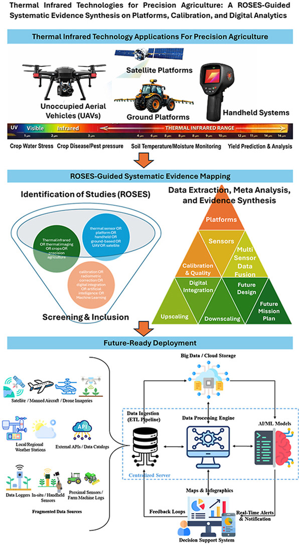
This research synthesizes evidence on the use of thermal infrared (TIR) sensing technologies for precision-based sustainable agriculture. While TIR sensing provides a unique physiological link between canopy temperature, crop water status, and evapotranspiration across unmanned aerial vehicle (UAV), handheld, and satellite systems, inconsistencies in scale, accuracy, and interoperability limit operational adoption. By harmonizing evidence across platforms and spatiotemporal scales, this study seeks to identify best practices, gaps, and integration pathways that enable reproducible, scalable, and automated TIR sensing workflows capable of supporting real-world agricultural decision-making. Novelty of this study underlies in a ROSES (RepOrting standards for Systematic Evidence Syntheses)-guided systematic review through five steps: literature search, screening and eligibility assessment, inclusion and data extraction, data analysis and mapping, and synthesis on thermal infrared sensing for agriculture. Six thematic domains were focused: sensing platforms and fragmentations, sensor technologies, calibration and data quality, cross-sensor fusion and scaling, digital analytics and integration (artificial intelligence (AI)/machine learning (ML), internet of things (IoT), automation), and future design. TIR sensing has shifted toward multi-platform, model-driven agricultural monitoring, but progress is methodologically uneven. Platform diversity and applications have expanded rapidly, while calibration consistency, uncertainty quantification, scaling, and cross-platform comparability remain limited. Evidence reveals biases toward post-2015 UAV studies, data-rich regions, and dense-canopy crops, constraining transferability and operational resilience across other geographic regions and cropping systems. TIR sensing has evolved into an ecosystem driven by data fusion, analytics, and digital infrastructure where UAVs dominate field-scale applications, while satellites support long-term monitoring. Calibration remains a major limitation, fusion improves interpretability, and scaling is underdeveloped. Rapid growth in digital workflows indicates integrated, validated computational pipelines to define future operational adoption.


 Address: No. 31 Fukang Road, Nankai District,Tianjin, 300191, P.R. China
 Website: https://aepi.caas.cn/en/
 Email: hbskjc@163.com